JOURNALISM MATTERS. By subscribing you help keep local journalism thriving.
AWARD WINNING COVERAGE Keeping you informed and connected to your community for more than 60 years.
Learn about your neighbors, what’s going on with local governments, high school athletes, local retailer promotions, and issues affecting the place we call home.
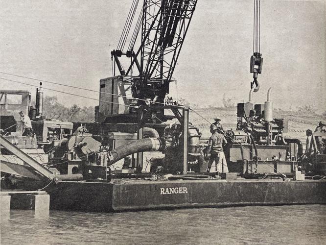
Mounds of earth aid contractors in the construction of the London Bridge in Havasu. The mounds were designed to the exact measurements of each of the bridge’s four arches. Lake Havasu Herald, 1970.
There’s a certain poetry in building a bridge across barren desert, with centuries-old stone spanning a channel of earth and dust beneath. Symbolic, some might say, of man’s dominion over nature – no matter how seemingly absurd its purpose might be.
A final draft of plans for the Bridgewater Channel, published in 1970.
Today's News-Herald archives
But when Lake Havasu City founder Robert P. McCulloch purchased the London Bridge by auction, and paid to have it shipped halfway around the world, he had something more literal in mind. The London Bridge might have been a $2.7 million accessory for Havasu, but the city’s appeal has always been – and might always be – its proximity to the water.
When the London Bridge came to Havasu, McCulloch was determined there would be water under it. But to make that happen, contractors would have to move more than 400,000 tons of earth to create what would be known as the Bridgewater Channel.
Mounds of earth aid contractors in the construction of the London Bridge in Havasu. The mounds were designed to the exact measurements of each of the bridge’s four arches. Lake Havasu Herald, 1970.
Today's News-Herald archives
The Channel didn’t begin as a single waterway, however. While the channel was still being built in 1970, multiple smaller channels were designed to allow workers the space they needed to rebuild the London Bridge across it.
Part of that construction included the formation of four hills of earth, where the bridge’s arches would eventually stand. The creation of those hills in 1970 ultimately aided construction of the bridge by reducing the amount of equipment necessary to lift each of the stones – some of which weighed more than 800 pounds, to where they would eventually lie.
The construction of the Bridgewater Channel, through what is now known as the Island, included more than 1,000 feet of seawall to protect the channel’s coastline from erosion – much of which still remains in the channel almost 50 years later.
The channel took almost two years to build before being opened, and water from the surrounding Colorado River was allowed to flow for the first time beneath the newly-constructed bridge.
The Bridgewater Channel lies at the base of what is now known as the Island. The Channel is about a mile long from its southernmost point at Thompson Bay, to its northernmost point at Lake Havasu State Park. At its widest, the channel is about six hundred feet long, accommodating the four arches of the bridge that now spans across it.
Keep it Clean. Please avoid obscene, vulgar, lewd,
racist or sexually-oriented language. PLEASE TURN OFF YOUR CAPS LOCK. Don't Threaten. Threats of harming another
person will not be tolerated. Be Truthful. Don't knowingly lie about anyone
or anything. Be Nice. No racism, sexism or any sort of -ism
that is degrading to another person. Be Proactive. Use the 'Report' link on
each comment to let us know of abusive posts. Share with Us. We'd love to hear eyewitness
accounts, the history behind an article.


(0) comments
Welcome to the discussion.
Log In
Keep it Clean. Please avoid obscene, vulgar, lewd, racist or sexually-oriented language.
PLEASE TURN OFF YOUR CAPS LOCK.
Don't Threaten. Threats of harming another person will not be tolerated.
Be Truthful. Don't knowingly lie about anyone or anything.
Be Nice. No racism, sexism or any sort of -ism that is degrading to another person.
Be Proactive. Use the 'Report' link on each comment to let us know of abusive posts.
Share with Us. We'd love to hear eyewitness accounts, the history behind an article.